During the 1700’s, cities began to be more formally planned according to central visions. Here are a few cities whose original plans were drafted during this century. In addition the century saw the first land use legislation in the United States.
Notable Cities
1701 Detroit

In 1701, a French officer, Antoine de La Mothe Cadillac, along with fifty-one French-Canadians founded a settlement called Fort Ponchartrain du Détroit. France offered free land to attract families to Detroit, which grew to 800 people in 1765; the largest city between Montreal and New Orléans. During the French and Indian War (1760), British troops gained control and shortened the name to Detroit.
Detroit passed to the United States under the Jay Treaty (1796). In 1805, fire destroyed most of the settlement. Augustus B. Woodward, Chief Justice of the Michigan Territory led the rebuilding. Judge Woodward devised a plan of a series of interlocking hexagons, inspired by L’Enfant’s layout for Washington, D.C. The plan was abandoned after only 11 years, but not before some elements were implemented, including the five main “spokes” of Woodward, Michigan, Gratiot, Grand River and Jefferson Avenues.
Detroit fell to British troops during the War of 1812, was recaptured by the United States in 1813 and incorporated as a city in 1815.* During the late 19th and early 20th centuries, many of the city’s Gilded Age mansions and buildings arose. Detroit was called the ‘Paris of the West’ for its architecture, and for Washington Boulevard, electrified by Thomas Edison. Strategically located along the Great Lakes waterway, the city emerged as a transportation hub. The city had grown steadily from the 1830s with the rise of shipping, shipbuilding, and manufacturing industries. In 1896, a thriving carriage trade prompted Henry Ford to build his first automobile in a rented workshop on Mack Avenue.
1733 Savannah

Savannah, along with the colony of Georgia, was founded on February 12, 1733, by General James Oglethorpe. In 1751 Savannah and the rest of Georgia became a Royal Colony and Savannah became the colonial capital of Georgia.
Savannah was laid out laid out in 1733 around four open squares. The original plan resembles the layout of military camps familiar to General Oglethorpe. The layout was also a reaction against the cramped conditions that fueled the Great Fire of London in 1666. There is also speculation that Oglethorpe was familiar with the similar layout of Beijing.*
Oglethorpe’s plan allowed the grid to grow with the city. By 1851 there were twenty-four squares in the city. In the 20th century three of the squares were destroyed. In 2010, Ellis Square one of the lost three, was reclaimed. Most of Savannah’s squares are named in honor or in memory of a person, persons or historical event, and many contain monuments, markers, memorials, statues, plaques, and other tributes.
1790 Washington DC

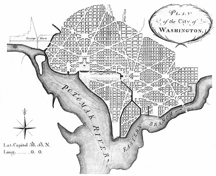
On July 16, 1790, the Residence Act provided for a new permanent capital located on the north bank of the Potomac, to the east of the established settlement at Georgetown. On September 9, 1791, the federal city was named in honor of George Washington, and the district was named the Territory of Columbia, a poetic name for the United States used at that time. Congress held its first session in Washington on November 17, 1800.
As outlined in the US Constitution, the original shape of the district was a 10 mile square. The city’s design was originally commissioned to Pierre Charles L’Enfant, by President Washington in 1791. L’Enfant was a French-born architect, engineer, and city planner who arrived in the colonies during the American Revolutionary War. He had previously designed Federal Hall in New York City, the site of Washington’s inauguration.*
The plan for Washington was modeled in the Baroque style, incorporating avenues radiating out from rectangles. L’Enfant’s design also envisioned a garden-lined “grand avenue” about 1 mile in length and 400 feet wide that is now the National Mall. L’Enfant viewed his commission as not only laying out the cities’ grid, but also planing the city and designing key buildings. This micromanagement led to L’Enfant’s firing by President Washington in March 1792. Although his replacement made revisions to the original plans, including changes to some street patterns, L’Enfant is still credited with the overall design of the city.*
Other Notable Cities
- 1738 Fort Rogue Now Winnipeg, Manitoba.
- 1749 Windsor Oldest continually inhabited settlement in Canada west of Montreal
- 1769 San Diego Grew from Presidio of San Diego.
- 1774 Unalaska Oldest Russian settlement of Aleutian Islands, dating to the 1760s. Permanent trading post established in 1774 (pdf).
- 1775 Tucson The town of Tucson had existed for over 2000 years at this point but this is the date the Spanish built a presidio and formally recognized the town.
- 1788 Marietta First permanent American settlement in the Northwest Territory
- 1793 Toronto Originally known as York, renamed in 1834.
Notable Events
Land Ordinance of 1785

The Land Ordinance of 1785 was adopted by the United States Congress on May 20, 1785. Under the Articles of Confederation, Congress did not have the power to raise revenue by direct taxation. The goal of the ordinance was to raise money through the sale of land in the largely unmapped Northwest Territory acquired at the 1783 Treaty of Paris after the end of the Revolutionary War.
The ordinance was the first standard for the subdivision of land in the United States.
Over three-fourths of the area of the continental United States ultimately came under the rectangular survey. This was important because it provided easily recognized land descriptions, which in turn contributed enormously to the orderly and largely peaceful occupation of the land. The rectangular survey also provided the units within which economic, political, and social development took place.
1 thoughts on “A Brief History of Urbanism in North America: 1700s”
Comments are closed.